Modeling Platforms for Regulatory Flood Risk Data Development: 2D vs. 1D

Jason Currie
Stormwater Engineer
The State of Flood Risk Data Modeling
Until recently, the use of 1D modeling platforms was the industry standard for developing nearly any kind of flood risk data or studies. However, as 2D modeling platforms such as ICM or HEC-RAS 5.0 and higher are improved and more widely understood by industry leaders, these programs are being used more frequently to help tackle the flooding challenges facing areas of the United States. The newer software allows for engineers to incorporate knowledge from big data into comprehensive flood risk data development strategies.
In 2016, the United States Army Corps of Engineers (USACE) released HEC-RAS 5.0, which includes new 2D rain-on-grid modeling methodology that allows modelers to conduct large-scale watershed-based 2D analyses not previously possible. Additionally, the latest ICM software has similar capability, but also includes the ability to model the sub-surface storm drainage infrastructure. Importantly, FEMA has not historically accepted ICM for use in regulatory modeling data development activities due to costs associated with its licensing fees. However, HEC-RAS is available at no cost through the USACE website.
Pilot Study: 2D vs. 1D Modeling for Flood Risk Assessments
In early 2020, the City of Charlotte and Mecklenburg County jointly engaged Freese and Nichols to produce a pilot study with two goals:
- To compare the benefits of a 2D approach to a traditional 1D approach for flood risk assessments, and
- To examine whether a single modeling solution could simultaneously address the data development needs of both entities.
The City of Charlotte, having authority over the “minor systems” that have less than one square mile of drainage area, was interested in the data generated for the headwaters of drainage basins where flooding conditions are often governed by the interaction between local runoff and the stormwater infrastructure. In the past, traditional FEMA studies have neglected these areas due to its focus on larger rivers, creeks, and streams.
Mecklenburg County, which oversees regulation of “major systems” that have more than one square mile of drainage area, sought locally relevant information that provides insight into the applicability of the full range of data that can be generated within the regulated floodplains.
For the study, Freese and Nichols modeled two separate watersheds within the City of Charlotte using both HEC-RAS 5.0 and ICM to have two 2D models to compare to the existing 1D model that was developed for the most recent county-wide FEMA flood mapping study. Once the 2D models were complete, our team reviewed and compared the flood depth, flood elevation and inundation extent data from each.
2D vs. 1D Modeling Approach Differences
The 2D modeling approach used in this pilot study includes fundamental differences from the previous model’s 1D methodology:
1D Modeling |
2D Modeling |
| Employs a steady flow methodology that applies a constant flow at fixed change locations throughout the study reach. | 2D Rain-on-Grid analysis uses unsteady flow that varies at each time step within the simulation interval, producing unique flows and elevations in each individual cell on the grid. |
| 1D model uses cross sections at specific locations to provide a limited approximation of the channel and floodplain geometries that convey runoff overland across the study area. | 2D grid is a detailed computational mesh created from the digital elevation model that thoroughly accounts for the impacts of the topography on storage volume and runoff conveyance throughout the watershed. |
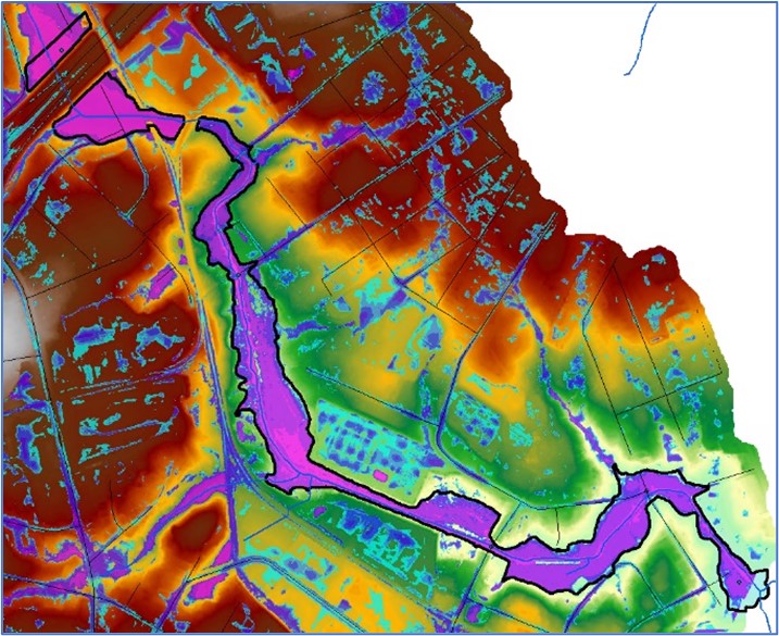
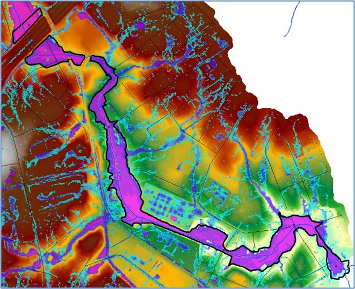
ICM 2D Model vs. 1D Effective Floodplain 2D vs. 1D Results
Freese and Nichols compared the results of both the HEC-RAS 5.0 2D model and ICM 2D model to those of the existing 1D model by reviewing 100-year event flood depths and 100-year inundation extents. In general, our team found that the inundation extents and 100-year flood elevations produced with both 2D modeling platforms compared favorably to those that were developed in the existing 1D modeling.
Below are sample comparisons for Stewart Creek Tributary 2. These images illustrate, in addition to flood information data for Stewart Creek Tributary 2, that the 2D rain-on-grid approach also produced flood depth and inundation extent information for all the small channels and streams within the watershed.
Benefits of 2D Over 1D
Our team found that the City of Charlotte, Mecklenburg County as well as other municipalities can greatly benefit from using 2D rain-on-grid models as a replacement for the current 1D models. Here’s why:
More Accuracy
Because the 2D approach uses fewer assumptions in the geometric representation of the floodplain, it yields results that more closely represent the actual conditions present in the model domain, including more accurate representations for the various hydraulic conditions that may exist in the county, such as interconnected flow paths, diverted or multi-directional flow scenarios, and complex roadway crossings.
Major and Minor Systems
2D rain-on-grid approach can produce comprehensive watershed-wide hydraulic datasets for both major and minor systems simultaneously.
Low Cost
The 2D model allows for a significantly larger studied footprint with only a relatively minor increase in cost.
Challenges and Adaptations
There are a few challenges in using a 2D approach, but there are also tenable, FEMA-supported solutions for them if local ordinances are adopted to accommodate them. Here are some to consider:
Challenge: The need for encroachment analyses.
- Currently, 2D modeling platforms do not have the capability of conducting encroachment analyses that have historically been used in developing floodways for new or updated FEMA flooding sources. In Mecklenburg County, this was particularly relevant due to the presence of both a FEMA floodway and a separate Community Encroachment Area that is used to regulate development within the floodplains in the major system.
Adaptations:
- Replace traditional surcharge floodways with a more data-driven non-encroachment area designation that is based on varying thresholds of “hazard” (defined as the product of flood depth and peak flow velocity).
- Adopt a “surcharge averaging” approach where the surcharges developed in the 2D encroachment analysis are determined along so-called “evaluation lines” where the average difference between the floodway and base flood elevation must be less than or equal to 1-ft.
- Adopt a surcharge determination approach that requires the surcharge at each model cell within the floodway be less than or equal to 1-ft.
- When either surcharge method is used for developing floodways, populate floodway data tables with data (flow area, velocity, etc.) extracted from the detailed output produced by the 2D model.
Challenge: No ability to develop traditional regulatory products.
- The fundamental difference in the composition of 2D models does not allow for development of regulatory products such as profiles and floodway data tables.
Adaptations:
- Determine water surface elevations within the regulatory floodplains with precision at every location within the model domain using WSEL rasters and computational data, the main output of 2D models. The state of North Carolina is a national leader in innovative risk communication using web-based GIS tools, and Mecklenburg County’s 3D Interactive Floodzone Mapping web service is at the forefront of this effort.
- Produce flood elevation profiles by extracting elevations from grid cells that are located along the stream centerline.
2D Modeling for the Future
The findings of the City of Charlotte and Mecklenburg County pilot study illustrate that 2D modeling with HEC-RAS or ICM software can support the floodplain management and regulation mission of various public entities with a small cost increase and high return on investment when compared to 1D modeling. And, with advancements of HEC-RAS in newer versions, modeling for event-specific flood forecasting and planning activities will become even easier.
Jason Currie, PE, CFM is a Stormwater Project Manager in Charlotte, North Carolina.