Using GIS for Faster Updates of Lubbock’s FEMA Floodplain Maps
The City of Lubbock wanted to update FEMA Flood Insurance Rate Maps that are more than 20 years old to reflect significant investments in stormwater infrastructure. The improvements have been removing properties from the floodplain and reducing risks, and the city has been undertaking the updates in phases to help reduce property owners’ flood insurance rates as infrastructure projects are completed.
Because of the area’s flat terrain and complex playa lake systems, Lubbock uses 1D ICPR software that meets their special modeling needs. But these models aren’t compatible with FEMA’s maps, so the city’s new data had to be manually added to the FEMA maps, a laborious process.
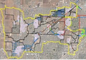
Lubbock sought a better solution. And the Freese and Nichols developed it, starting with an area designated as System B, covering 19 square miles, 20 Playa Lakes and 12.5 miles of stream length.
Customizing GIS tools to meet the need
The Freese and Nichols stormwater team transformed a traditionally manual, time-intensive FEMA mapping process into an efficient, GIS-driven workflow tailored to Lubbock’s unique 1D ICPR modeling approach. By developing a custom suite of tools that automate floodplain delineation, flood profile generation, and web-based visualization, the project significantly reduced mapping time from days to hours, which empowers both the City and local developers.
Among the innovations:
- Using ArcGIS ModelBuilder to automate floodplain mapping directly from ICPR results. This reduces what previously took days of active, manual work into a repeatable background process completed passively in hours.
- Adapting a flood profile generation tool that Freese and Nichols originally built for HEC-RAS to support ICPR outputs. This eliminates the need for manual CAD drafting and makes it possible to complete submittals for large areas with greater accuracy, speed and consistency.
- Creating an interactive ArcGIS Online webmap that allows city staff to explore model components, floodplain boundaries and building footprints in a clear, accessible format. This improves communication across departments and encourages community engagement.
Providing benefits to city staff and property owners
The mapping tools reduce workload by speeding up the map conversion process; minimize human error; and help streamline FEMA review. More accurate maps will lower unnecessarily high flood insurance rates for properties no longer located in the most hazardous areas. And the city can apply this solution to future phases of map updates when other stormwater projects are finished.
This project recently won a Horizon Award, a quarterly award at Freese and Nichols given to projects that encapsulate our culture of innovation.