Taking Drones to New Heights for Your Projects

Brian King
Geographic Information System Specialist

Dan Christiansen
Construction Manager
For the engineering and construction industry, drones aren’t a novelty any more or even a luxury — they’re increasingly a vital tool for sophisticated project documentation, modeling, inspection, data collection and more.
Their uses are as broad and varied as you can imagine:
- Facilitating collaboration, especially during virtual meetings, with close-up views delivered online, even in real time
- Applying thermal imagery for such diverse tasks as pinpointing the source of water leaks, detecting energy inefficiencies or even locating feral hogs in dense, sensitive wildlife habitat
- Assisting analysis involving erosion, land use and crop heat stress
- Aiding inspections of water towers, power lines, confined spaces, roofs, roads and bridges
- Supporting emergency management and public safety/security efforts
And because drones can access hard-to-reach or dangerous areas, achieve high positional accuracy and offer survey-grade precision and high-resolution images, they offer advantages over traditional methods, including savings of time and money.
How drones can elevate your project
Enhance construction documentation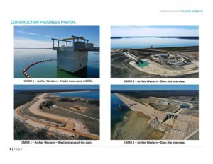
Drone flights can be saved to a file that the pilot can use over and over again to fly the same exact mission, allowing photos and videos over the course of construction to provide a time-lapse view of progress or changes.
Example: Regular drone flights at Bois d’Arc Lake, the first major reservoir built in Texas in 30 years, have enabled the North Texas Municipal Water District to track progress over four years of construction for this new water source for some 2 million people. Photos and video footage have helped managers keep NTMWD officials informed and have provided an important public face for the project. Click to view monthly Bois d’Arc Lake videos.
Provide specialized views
Virtual tours can be created using a 360-degree camera. Specialty lenses that capture sharper, more expansive views at lower elevations can be incorporated with cinematography to create compelling public presentations that help agencies generate public excitement about projects. A sonar sensor can produce imagery where LiDAR can’t, such as for documenting depths of reservoirs and streams and showing underwater contours.
Improve inspections and verification
Drone footage can capture the entire project, track progress in a side-by-side comparison, corroborate work done and provide a virtual 3D record, increasing efficiency and reducing risk/liability. Live-streaming video can assist with real-time assessment and feedback. Stored images can be marked up at a later, more convenient time, to address issues they reveal.
Example: At Upper Trinity Regional Water District’s Lake Ralph Hall, another major North Texas reservoir under construction, drone flights using Pix4D software are documenting progress.
Pix4D has multiple other applications, depending on need: For instance, it could be used to measure an area of tree clearing and topsoil stripping to help with pay request reviews. The software can record underground utility locations for future reference. Using the software can improve the accuracy of data and assist with map comparisons and high-resolution virtual inspections.
Provide digital as-builts
Once construction is completed, a final drone flight can be stored in BIM format as an as-built to assist with closeout. This method offers the advantage of viewing the digital file online and easily reviewing minute details. The as-built also can be stored with a pre-project flight of the project site, giving additional insights into how well the project accomplished its goals.
Tackle emergency needs
In a crisis situation, a drone flight can document provide real-time views for evaluation, even reaching hard-to-access locations, such as in the event of a flood that washes out roads or bridges. Footage can be shared across multiple geographies, facilitating collaboration.

Building a drone program
Drones are governed by Federal Aviation Administration regulations as well as some state laws. For instance:
- To operate a drone for commercial use, pilots must obtain an FAA Part 107 certificate (valid for two years) by passing an Initial Aeronautical Knowledge Test. Pilots must be 16 years old; be able to read, speak, write and understand English; and be in a physical and mental condition to safely fly a drone.
- Flight limitations include a maximum groundspeed of 100 mph, maximum altitude of 400 feet Above Ground Level or within 400 feet of a structure, and minimum weather visibility of 3 miles.
- Pilots can’t operate from a moving vehicle unless operation is over a sparsely populated area. They also can’t operate directly over people or directly moving vehicles and must yield right of way to other aircraft.
How Freese and Nichols can help you
With 12 drone pilots on staff across our offices, our teams have helped cities and water districts using new imaging technologies via air, land and water. We can assist with:
- Construction progress documentation
- Applying thermal imaging for multiple uses
- 2D and 3D modeling
- Project site inspections and dam inspections
- Video development for marketing and meeting collaboration
- Drone flights for emergency management
To learn more or for assistance, contact: Brian King, GISP, RPA, CFM, brian.king@freese.com, 512-617-3175, or David Smith, dds@freese.com, 817-735-7344
Brian King, GISP, RPA, CFM, is a Geographic Information System Specialist and approved drone pilot in Austin.
Dan is a Construction Manager and an approved drone pilot based in North Texas.