The Dillard Wetland Restoration: Reducing Flood Risk and Creating a Healthy Retreat for New Orleans

Nina Reins
Water Resources Engineer
The city-owned Dillard Wetland is a 27-acre parcel of forested low-lying land on the west side of the London Canal and is one of the last remaining parcels of wetland/forest within New Orleans city limits. More than 17 years earlier, this area was significantly impacted by Hurricane Katrina and is still recovering, so this hydrologic resiliency project is designed to increase stormwater retention capacity and reestablish healthy wetland vegetation and to provide a retreat from urban life with a variety of community improvements.
With funding through the U.S. Department of Housing and Urban Development (HUD) National Disaster Resilience Competition (NDRC), the City of New Orleans has undertaken an unprecedented network of integrated innovative water management initiatives across the Gentilly neighborhood. The established Gentilly Resiliency District (GRD) projects will reduce flood risk, slow land subsidence, spur economic opportunity, improve health, encourage neighborhood revitalization, and adapt the city to a changing environment, while establishing design approaches that can be reapplied in other neighborhoods. These GRD projects, including the Dillard Wetland Project, encompass green infrastructure features using vegetation, soils and natural processes to manage water and create healthier urban environments. Freese and Nichols has provided field investigations, community engagement, planning and design services and will continue its support throughout construction implementation and monitoring.
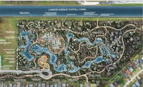
Design Features
Taking into account all of the goals for this project to reduce flood risk and elevate the neighborhood as a whole, the design features include:
- Piping and a 30 CFS pump station to route existing rainwater from adjacent streets into the wetlands during peak flows
- New grading to manage ponding areas, hydraulic zones for various wetland species and the overall residence time of the stormwater flows
- A Vegetation Management and Control Plan to remove invasive species trees, restore native plants, to manage vector species in the wetlands, and to improve the health of the ecosystem
- Boardwalks through the forest to provide access to outdoor classroom, playground, and recreational spaces
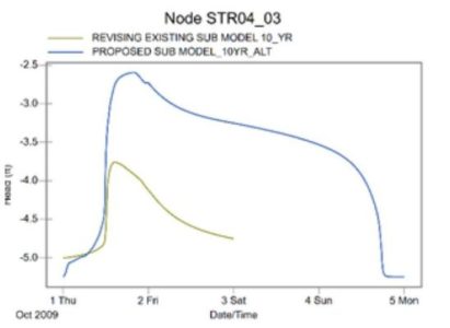
The proposed project features, such as specific types and locations of the green infrastructure and stormwater management installations/improvements, are based on a comprehensive hydraulic and hydrologic study and extensive flood modeling for the project site and its surrounding area.
Triple-Bottom-Line Benefit-Cost Analysis
The required Triple-Bottom-Line Benefit-Cost Analysis accounts for traditional benefits, such as reduced flood damage, and includes many other benefits accounted for leveraging the benefit-cost ratio, such as property value uplift, educational benefits, improvements to water quality and public health benefits from exercise, access to the site and reduced stress and/or healing through forest bathing and community recreation.
Community Engagement
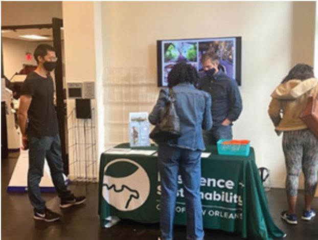
A robust community engagement plan was developed and implemented, with continued COVID-19 adaptation, and it has been extremely successful for continued stakeholder involvement and overall project acceptance. Events included early one-on-one meetings with key stakeholders and community leaders, neighborhood canvassing and pop-up events, public Resilience District Review Committee Meetings, informative virtual seminars and other community events. In addition, monthly calls are held with all firms, agencies and nonprofits participating in the overall GRD effort. Freese and Nichols has further presented project progress at local nonprofit organizations and local conferences and has reached out to outdoor programming stakeholders, including universities and teachers, to establish the foundation for long-term interest and stewardship of the site.
 Construction-Phase Tree and Vegetation Protection
FNI’s services for the project include providing engineering services during construction to confirm proper contractor execution of the project’s innovative design components and to provide construction-phase tree and vegetation protection and invasive species vegetation removal oversight.
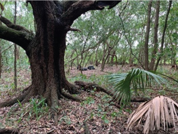
The required Invasive Species Management Plan included a detailed survey of plant/tree locations, plant species and tree diameters to determine the type and density of invasive species and to preserve native vegetation areas, particularly areas with mature oak trees. Mechanical and chemical invasive species controls were identified to treat existing species and manage the site in the longer term to prevent the reestablishment and spread of invasive species into wetland restoration areas. The plan includes several management techniques for identified invasive species and complements the comprehensive planting plan that was prepared for the site. The objective of the planting plan is to establish a closed-canopy, self-sustaining native species bottomland hardwood forest that would represent predevelopment wetland conditions. Species were selected to reflect planned site hydrology and include bald cypress, a variety of native oaks and a native herbaceous seeding plan. The planted species will also deter the spread of invasive species, which generally require open canopy space to become established.
Education Opportunity
For more on hurricane-related topics, see Freese and Nichols Stormwater Engineer Katie Jones at the upcoming Louisiana Civil Engineering Conference at her presentation “CERA and HAZUS-MH – Using Publicly Available, Real-Time Data to Estimate Loss during Hurricane Season.”
Nina Reins, PhD, PE, PMP, is a senior coastal project manager in New Orleans.